Can I find hiking trail maps at trailheads around Mallorca?
Similar Topics
hiking maps
serra de tramuntana
trailheads
tib bus network
puig major
mondragó park
formentor hiking
digital maps
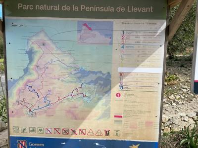
Detailed maps are generally available at many of the main trailheads across the island, especially in well-trodden hiking zones like the Serra de Tramuntana. Near towns such as Sóller, Valldemossa, and Deià, you’ll often find informative kiosks or visitor points offering printed maps that outline route distances, difficulty, and key landmarks like Puig Major or Torrent de Pareis. These tools help walkers plan their days, whether aiming for a challenging summit or a gentler coastal path.
In places like the Parc Natural de Mondragó, where trails weave through pine forests and along turquoise coves, printed maps tend to be complemented by useful signage marking viewpoints and rest spots. The local TIB bus network sometimes distributes brochures at main stops that include hiking information, enabling seamless transitions from public transport to trailheads. For more immersive planning, digital maps and apps that rely on GPS make it easier to navigate less marked tracks and avoid getting off course.
When exploring around Alcúdia or the iconic Formentor peninsula, it’s wise to check in with local tourist offices or accommodation hosts who often keep extra maps and offer firsthand advice about trail conditions. Whether you rely on a classic paper map or use a phone app, understanding the terrain beforehand—particularly the steep climbs up from Cala Llombards or along the Ma-10—ensures a safer and more rewarding walk. Taking a moment to gather your resources before setting out means you can savor the island’s rugged beauty without undue concern about directions or timing.
In places like the Parc Natural de Mondragó, where trails weave through pine forests and along turquoise coves, printed maps tend to be complemented by useful signage marking viewpoints and rest spots. The local TIB bus network sometimes distributes brochures at main stops that include hiking information, enabling seamless transitions from public transport to trailheads. For more immersive planning, digital maps and apps that rely on GPS make it easier to navigate less marked tracks and avoid getting off course.
When exploring around Alcúdia or the iconic Formentor peninsula, it’s wise to check in with local tourist offices or accommodation hosts who often keep extra maps and offer firsthand advice about trail conditions. Whether you rely on a classic paper map or use a phone app, understanding the terrain beforehand—particularly the steep climbs up from Cala Llombards or along the Ma-10—ensures a safer and more rewarding walk. Taking a moment to gather your resources before setting out means you can savor the island’s rugged beauty without undue concern about directions or timing.

More Fotos


Related Questions
Related Question
Are there safe, designated playgrounds for young children in Mallorca?
Related Question
Is it possible to book a table in advance at beach bars like Es Trenc’s Salt Beach Club, or do they usually operate on a first-come, first-served basis?
Related Question
Where can I find the best scenic viewpoints with panoramic views on Mallorca?